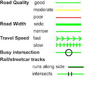
Want to do some mapping on your own? Pick one (or more) of the posted maps and fill it out according to the key. Don't see your neighborhood? Don't worry, it will be posted soon!
Thursday, July 17, 2008
Example maps
Here are some examples from last week. Feel free to make special notes on the side or next to roads.
These are great! Show me more 6th and 7th ward! Also, if there is space or as a step 2 once basic transportation coding has been identified, you should have people identify "stopping" points. These could be used for future trails and for economic development arguments.
Sure things, Mama. This is just a starting point for the DIY maps. The plan is to try to knock out all the neighborhoods with the mapping events and DIY maps by Mid-September. I know there are a lot of people working on identifying community assets in the city, so hopefully we can combine forces to produce something more fun that just streets.
Open street map doesn't have all this data yet. Once everything is collected, anyone will be able to add it onto the Open Street Map or any other free, open source to help promote cycling in New Orleans!
If you're busy during mapping events, you can still participate by mapping on your own free time. Pick a map posted, and then make a comment saying you are going to map this area. Once you've completed the map, make another comment that you've finished it. E-mail lauren@nolacycle.com with a color scan of your map. If you don't have a scanner, e-mail me for my mailing address so you can send it.

.jpg)
5 comments:
These are great! Show me more 6th and 7th ward! Also, if there is space or as a step 2 once basic transportation coding has been identified, you should have people identify "stopping" points. These could be used for future trails and for economic development arguments.
Sure things, Mama. This is just a starting point for the DIY maps. The plan is to try to knock out all the neighborhoods with the mapping events and DIY maps by Mid-September. I know there are a lot of people working on identifying community assets in the city, so hopefully we can combine forces to produce something more fun that just streets.
Great job! Almost makes me want to move back to NOLA!
Why not use OpenStreetMap data for this?
Open street map doesn't have all this data yet. Once everything is collected, anyone will be able to add it onto the Open Street Map or any other free, open source to help promote cycling in New Orleans!
Post a Comment